First appeared in

Asian Development Bank
100 Climate Actions from Cities in Asia and the Pacific
A city-level initiative that is the first of its kind in India will allow communities in Kolkata to learn from past events and act swiftly in the face of disaster through forecasts, real-time information, and a wide range of climate data.
A city-level initiative that is the first of its kind in India will allow communities in Kolkata to learn from past events and act swiftly in the face of disaster through forecasts, real-time information, and a wide range of climate data.
Kolkata Municipal Corporation is working to make Kolkata a smart and resilient city by reducing urban flood risks through the introduction of a flood forecasting and early warning system.
Kolkata is one of the densest megacities in the world, and is consistently ranked in the top 10 most vulnerable cities due to its high risk of flooding under climate change projections. The new system is composed of a low-cost, high-density network of 350 sensors that will provide real-time information on flooding, air quality, heat stress, and humidity, the data from which will enable remote monitoring via the “Kflood” website.
6K
HECTARES EXPECTED TO SEE REDUCED FLOODING
HECTARES EXPECTED TO SEE REDUCED FLOODING
Since most floods in Kolkata are caused by local rains, the response time is often less than one hour. The construction of an early warning system will benefit residents by providing timely warnings about impending disasters, reducing the economic loss and impact on livelihoods for vulnerable communities.
The project has been implemented under ADB’s Kolkata Environmental Improvement Investment Program (KEIIP), supported on a grant basis by the Urban Climate Change Resilience Trust Fund.
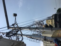
By including a wide range of data from flood sensors like this one, the new system can be utilized year-round, instead of only during monsoon season like traditional forecasting systems (photo by UCCRTF).
The Challenge
Flat terrain and insufficient drainage amplify flooding and water logging in the city, which experiences heavy rains during the monsoon season.
Co-Benefits
Economic The project’s cloud-based platform reduces operational costs associated with physical servers, and site-specific warnings can reduce losses for businesses.
Environment The time series data provided by the system can inform studies on heat stress and air quality, allowing the city to create sustainable urban plans.
Social Early warnings systems and real-time inundation data allow the city government to plan and disseminate evacuation information to vulnerable populations.